诗书乐及大自然
让诗词书法, 音乐及精彩的大自然美化及充实我们的生活 - 伊梅邀请您
双彩虹(Double Rainbows),雨后(after rain) 在墨尔本市中心的西南部分及港口或海湾小区(Docklands)(多片片)
最近从墨尔本市中心的西南部分及港口或海湾小区(Docklands)搬到郊区住,忙死了。
现在贴几张几个月前照的那里雨中双彩虹和雨后的照片,还有当时住的公寓楼(租了整一年),和港口或海湾小区(Docklands)的风貌。
雨中双彩虹(double rainbows)出现在市中心西南部分和港口或海湾小区(Docklands)。
雨中整个彩虹跨过市中心西南部分和港口或海湾小区(Docklands)。
雨中双彩虹出现在市中心和港口或海湾小区(Docklands)。
雨后天晴(after rain),从港口或海湾小区的向市中心看,放大看悬空的锚(请见以下的解释)。
从港口或海湾小区的向市中心看,放大看悬空的锚(请见以下的解释)。
从港口或海湾小区的向南看, 可以看到墨尔本南边的海湾。
港口或海湾小区的一部分,远处是西门大桥,近处是宁静的海湾。还有一个艺术表示的牛仰天躺在树叉上,很舒服的样子。
港口或海湾小区的一部分,远处是西门大桥,近处是宁静的海湾,其内停泊着许多富人的游艇等,右边岸上是众多的餐馆。 
港口或海湾小区的一部分,远处是西门大桥,近处是宁静的海湾, 岸上是墨尔本特色的有轨电车。
港口或海湾小区的一部分,展示出一舞台,在此常有时装猫步表演等。
港口或海湾小区的一部分,有许多办公楼,正面为澳大利亚的银行总部(National Australia Bank - nab)大楼。这里正在修电车的新轨道,所以比较乱些。
我们租的公寓的侧面,这座楼象征着一帆船,英文名为Victoria Point。位于著名的Etihad Stadium(or Telstra Dome) 的旁边(见左边的部分)。
我们租的公寓的背面,可见一个悬空而吊立的锚,因为这座楼象征着一帆船。
艺术品展示在Telstra Dome 的平台上。
More information about Docklands can be found in:
Docklands, Victoria
| Docklands Melbourne, Victoria | |||||||||||||
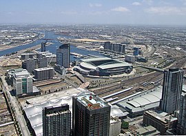
 View toward Docklands from high above the Melbourne CBD in 2008. From left to right - Batmans Hill & Southern Cross Station; Victoria Harbour; Stadium Precinct; New Quay; Waterfront City; Digital Harbour | |||||||||||||
| Population: | 3939 (2006)[1] | ||||||||||||
| Established: | 2000 | ||||||||||||
| Postcode: | 3008 | ||||||||||||
| Area: | 3 km² (1.2 sq mi) | ||||||||||||
| Location: | 2 km (1 mi) from Melbourne CBD | ||||||||||||
| LGA: | City of Melbourne | ||||||||||||
| State District: | Melbourne | ||||||||||||
| Federal Division: | Melbourne | ||||||||||||
| |||||||||||||
Docklands (also known as Melbourne Docklands to differentiate it from London Docklands) is an inner city suburb in Melbourne, Victoria, Australia occupying an area extending up to 2 km west of and adjacent to Melbourne's Central Business District (CBD). Its Local Government Area is the City of Melbourne. Demographically, Docklands has a population, according to the 2006 Census, of 3,939.
Docklands is bounded by Spencer Street, Wurundjeri Way and Charles Grimes Bridge to the east, CityLink to the west and Lorimer Street across the Yarra to the south.
Docklands is a primarily waterfront area centred around the banks of the Yarra River. The area is the product of an ongoing urban renewal project to extend the area of the CBD (excluding Southbank and St Kilda Road) by over a third when completed around 2015.
Docklands includes the Melbourne landmarks Etihad Stadium, Southern Cross Station and The Southern Star Ferris wheel.
From the 1880s, the Docklands were used for docks, rail infrastructure and industry but mostly fell out of use following the containerisation of shipping traffic. The space remained vacant and unused during the 1980s and it fell in to disrepair. Docklands became notable during the 1990s for its underground rave dance scene,[2] a dance culture which survives through popular organised events held at Docklands Stadium.
The stadium (then known as Colonial Stadium) in 1996 was built as a centrepiece to kick-start developer interest in Docklands as a viable renewal area. Urban renewal began in earnest 2000 as a collection of several independent but themed developments with staged development milestones. The project was tendered out and overseen by VicUrban, an agency of the State government of Victoria. The brief for the master plan was for wide open water promenades and road boulevards with contributions of landscaping and public art commissions to be made by each developer. VicUrban promotes its vision of Docklands as being a major tourist attraction with projections of over 20 million visitors a year and having a future (2015) residential population of over 20,000.
Despite being almost completely redeveloped, Docklands does retain a handful of significant heritage buildings mostly related to the area's industrial and maritime history. Most of the heritage buildings remaining on the site have been redeveloped and integrated into the development or will be in future.
Docklands has become a sought-after business address,[3] attracting the national headquarters of National Australia Bank, ANZ, Medibank Private, Bureau of Meteorology, Myer, National Foods as well as the regional headquarters for AXA Asia Pacific, Ericsson and Bendigo Bank.[4] The Business Park model of large low-rise campus -style office buildings combined with transport and proximity to city centre is seen by many in the real estate industry to be one of the reasons behind the success of the Docklands office market.
While still incomplete, Docklands developer-centric planning has been widely criticised and many Melbourne politicians and media commentators lament its lack of green open space,[5] pedestrian activity, transport links and culture.[6][7][8]
Contents[hide] |
[edit] History
Before the Foundation of Melbourne, Docklands was a wetlands area consisting of a large salt lake (on the current site of Victoria Harbour) and a giant swamp (known as West Melbourne Swamp) the at the mouth of Moonee Ponds Creek. It was one of the open hunting grounds of the Wurundjeri people who created middens around the edges of the lake.
At Melbourne's foundation, John Batman set up his home on Batman's Hill at Docklands, marking the westernmost point of the settlement. However the rest of Docklands remained largely unused for decades.
The advent of rail infrastructure in the late 1860s saw the city's industry gradually expand into the Docklands area.
The earliest plans to redevelop Docklands came in the 1870s when a plan was prepared to extend the Hoddle Grid westward , following the curve of the Yarra River effectively doubling its size. The plan included several gridlike blocks with an ornamental garden and lake in the shape of the United Kingdom to occupy the site of the salt lake.
However the proposal was abandoned in favour of extending the city northward and a major engineering project began in the 1880s to reroute the course of the Yarra River and this resulted in the widening of the river for shipping and the creation of Victoria Docks. Light industry grew to surround the western rail yards of Spencer Street railway station (Now Southern Cross railway station.)
By the 1920s, with shipping moved from the Yarra turning basin at Queensbridge, Docklands had become the busiest port of the city.

(from: http://en.wikipedia.org/wiki/Docklands,_Victoria)


谢谢丽雅美言,也预祝你和家人圣诞快乐!周末好。
yimei妹妹的双彩虹照拍得很美。
谢谢分享。妹妹圣诞快乐!