快乐的太阳狗和霹雳猫
Life is so much fun, we just need to go out and explore...


去台湾出差多次,见到有趣的瞬间就会举起手机记录下来,零零碎碎形成了一些台湾印象。
_________________________________________________
淡水落日和街头歌手:

夕阳下的大榕树:

淡水镇位于淡水河入海处,捷运可达,是台北市民周末消闲的热点。另外周杰伦是淡江高中毕业,也有不少歌迷来朝圣。
_____________________________________________
在乡间游走的竞选车:

赶上台湾九合一选举,气氛还是满热闹滴!
________________________________________________
心事重重的中年妇女从龙山寺里走出来:

龙山寺一角:女生拜月老,男生拜关帝(除了一个斜背Purse的):

龙山寺位于台北万华区,是台北香火最盛的寺庙。万华旧称艋舺,是台北的发源地。福建人移民台湾的早期据点有“一府二鹿三艋舺”的说法,指的就是台南府,鹿港,艋舺。 作为老区,这里向来是龙蛇混杂之处。電影“艋舺”就是这一带八十年代的故事,很多场景是在旁边的剥皮寮老街拍摄的。现在这是个文艺区,有不少有意思的小型展览:

展厅里年轻的工作人员安静的看一本线装书:

地铁站内练舞的年轻人:

板桥市中心的圣诞灯饰,年轻人的热点:

相对来说,台湾的年轻人比较心平气和。有一次和公司台湾分部的小年轻聊天,问“最近台北的年轻人流行啥?”答曰:“小确幸。”
台湾总体人文环境不错,治安也好。有一次台湾的同事带我去永康街吃饭,转来转去找不到车位,最后停在很远的僻静路边。我正要背上沉甸甸的电脑包,结果同事说没事放心吧,把他的电脑包就大剌剌的丢在后座上。吃完饭回来,果然车和两个电脑包都无恙,这在旧金山是不可想象滴!
———————————————————
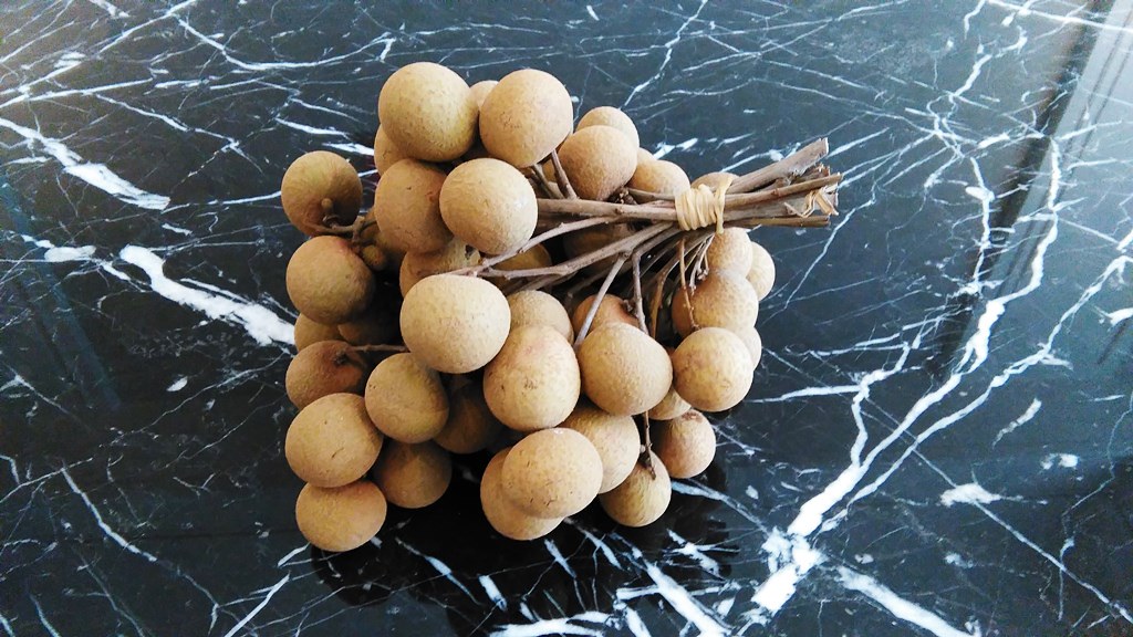
台北巷子里水果摊下打瞌睡的猫咪:

在摊子上买了好大好甜的龙眼,甜到可以代替跑步用的能量胶:
周末清晨的台北车站地下街,空无一人,经常从这里跑步去淡水河畔的自行车道:

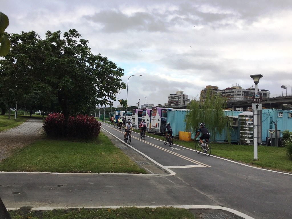
淡水河右岸自行车道是晨跑的好地方,堤墙挡住了东方的太阳,在炎热的夏季很有帮助:

我们一起跑步的朋友有好几个经常去台湾出差,太阳狗特地写了下面的介绍给他们。是给外国人的指南性质,比较罗嗦,就不翻译回中文了。
A couple good runs in Taipei
I am sharing two of my favorite long runs in Taipei.
Tamsui river right bank bike trail – for a long flat run:
The bike path is 15 miles long, and longest run I did on it was an out-and-back 20 miler.

To get on the bike trail form Taipei city, I had to go thru one of the access gates in the levee wall. I took the one at the west end of Zhengzhou Road, which is about 500m west of the Beimen MRT (subway) station:


Cars can only come out of this gate, not getting in. If you are taking a taxi, Dadaocheng Pier Plaza (about ½ mile north) is a better starting point.
The bike trail is just beyond the gate:
From here I ran north along the river, and the view was not bad:


There are many vending machines along the trail, where you can buy water and sports drink:
 Most of them taking coins, and a few of them also taking Easycard:

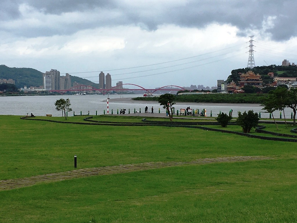
At mile 6, I reached the tip of the peninsula. There was a friendly old man selling homemade juice (very tasty):

Tamsui River and Keelung River meet here, and I enjoyed the expansive view:
The beautiful temple across the river attracted my attention, and I decided to make it my turn around point. So I continued east for two miles along Keelung River and then crossed the Shezi Bridge:

After the bridge, running on the other side of Keelung River for two miles, I reached the beautiful Guandu temple exactly 10 miles from where I started:


The trail continues for another 5 miles to the sea, however I turned around and run back to where I started.
————————————————
Yangmingshan National Park Transverse – for a hill training:
With the group doing multiple tough hills in preparation for our Grand Canyon R2R trip, I felt pressured enough to do one hill training while I was in Taiwan. The Yangmingshan National Park was a natural choice of location. There are extensive hiking trails in the park. Actually the park authority was holding a transverse challenge, for hikers to reach all the ten peaks in the park. At each peak, there is a wooden post with one Chinese character on top of it. Adding all the characters together, it will read “Yangmingshan East to West Transverse Challenge” (阳明山东西大纵走活动).

It was designed for a 12 hour hike, and I did 8 of the 10 peaks in 5 hours:

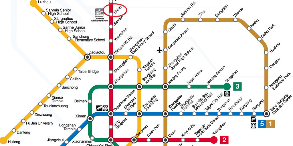
To get to the start point, Fengguizui, I took the red MRT to Shilin station:
I jumped in a taxi outside of the station, and it took me passing the National Palace Museum, then on a winding mountain road with many unnerving blind curves up to “Fengguizui”:

The trail was nice and gentle for the first part:
I ran pass the first the first peak without noticing it, but found the wooden post marking the 2nd peak:

The 3rd peak (Zhugao Peak) is more pronounced (left in the picture below):

From Zhugao Peak, looking south to Taipei city:

Looking north to Qixing peak, the highest one on the trail:

Coming down Zhugao peak, I ran back to the main trail. Soon I was greeted by a nice looking bridge, where I took a picture with Qixing peaks in the background

There is a service center after the bridge, where a steep stone stairway leading up to Qixing peaks. It was so steep that I had to stop running and start walking. Great view halfway up Qixing peaks:

After countless stone steps, I reached the Qixing east peak. However, the real highest point, Qixing west peak, still a little further:

Finally I was on the top of Qixing peak, the highest point in Taipei city:

The Chinese character “West” mark it as the fifth peak in the transverse challenge:

Going down the peak, I ran past a couple small volcanic blow holes:

 There is a service center (Xiaoyoukeng) near the blow holes, where water and food are available:

From the service center the trail leads to Balaka Highway. Hikers need to travel on the highway for a while. The cars I encountered gave enough room for me and other hikers.
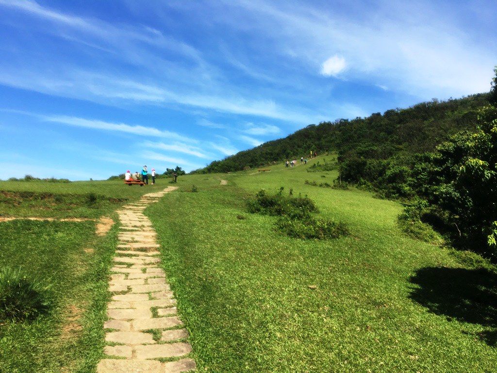
After about a mile on the highway, a sign bought me back to the trail, where a steep stone stairway leading up to Datun mountain:

The view was getting wilder at this point:

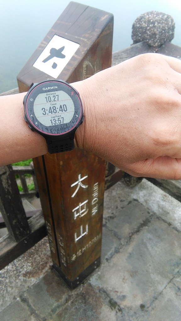
Reached the 2nd highest peak in the park, Datun Main Peak, after another steep climbing:
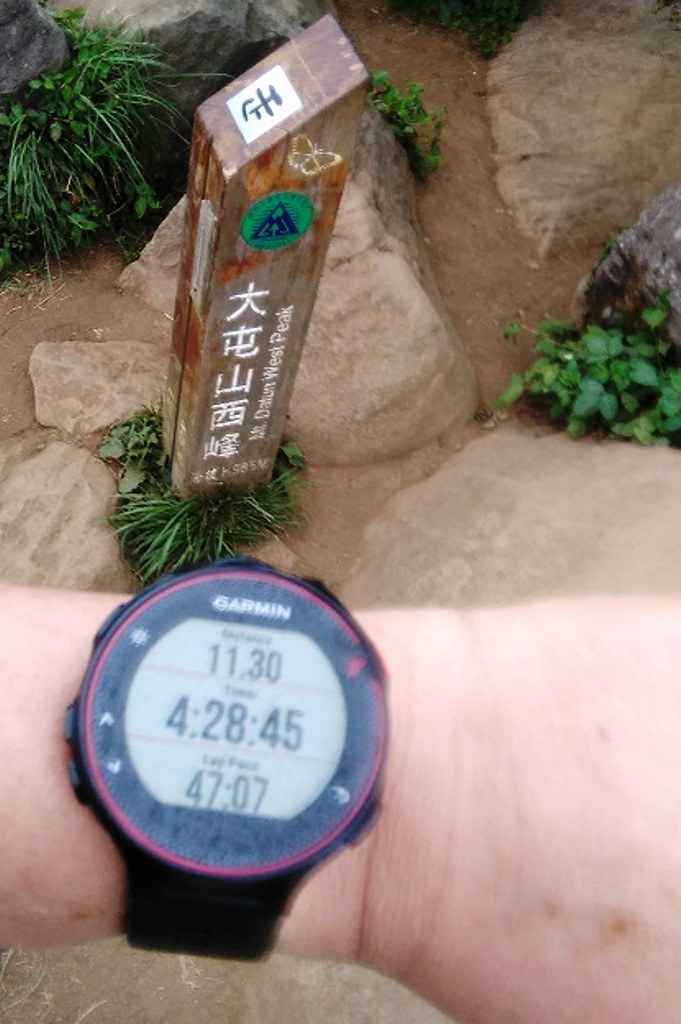
There are three peaks in Datun Mountains: Main Peak, South Peak and West Peak. The trail was in good shape until the South Peak:

Between Datun South and West Peaks, as well as the way leading down West Peak, the trial was primitive, where ropes were in place to aid the hikers:

After four and half hour of running, walking, climbing and panting, I finally reached the west peak, the last one for the day:
From here, you can do an additional 2 mile loop to reach two more small peaks (Xiantianshan and Miantianshan), or you can take the trail straight down the mountain as I did.
This small temple marks the end of the trail:

From here, a regular mini bus service links to Beitou station of the Red MRT line.